D6.3 Future CCII-T1 scenarios for Europe
 This report documents the work on producing climateclimate
Climate in a narrow sense is usually defined as the average weather, or more rigorously, as the statistical description in terms of the mean and variability of relevant quantities over a period of time ranging from months to thousands or millions of years. The classical period for averaging these variables is 30 years, as defined by the World Meteorological Organization. The relevant quantities are most often surface variables such as temperature, precipitation and wind. Climate in a wider sense is the state, including a statistical description, of the climate system
data that is focussing more on the needs of the impacts communities. The work has progressed along two main lines. Firstly, the development of methods and tools for processing the basic meteorological variables, like precipitation and temperature, to produce various impact-oriented measuresmeasures
In climate policy, measures are technologies, processes, and practices that contribute to mitigation, for example renewable energy technologies, waste minimization processes and public transport commuting practices. or Tier-1 Climate ChangeClimate Change
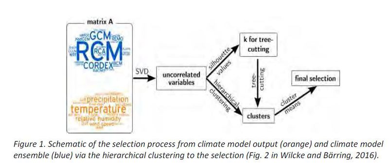
Climate change refers to a change in the state of the climate that can be identified (e.g., by using statistical tests) by changes in the mean and/or the variability of its properties, and that persists for an extended period, typically decades or longer. Climate change may be due to natural internal processes or external forcings such as modulations of the solar cycles, volcanic eruptions and persistent anthropogenic changes in the composition of the atmosphere or in land use. Note that the United Nations Framework Convention on Climate Change (UNFCCC), in its Article 1, defines climate change as: 'a change of climate which is attributed directly or indirectly to human activity that alters the composition of the global atmosphere and which is in addition to natural climate variability observed over comparable time periods'. The UNFCCC thus makes a distinction between climate change attributable to human activities altering the atmospheric composition, and climate variability attributa Impact Indicators (CCII’s). Tier-1 indicators are those that can be calculated from climate data only (i.e. commonly available data about the physical climate system). In the second line of work we have developed and applied a procedure for finding reduced representative ensemblesensembles
Running a GCM model multiple times only changing the initial conditions can at times simulate extended periods of quite different climate change signals for a specified area. This is due to the natural variability of the climate system, and it is impossible to state which circulation change is more likely to occur in the future. This limits our ability to place tight bounds on estimates of regional climate change.
The work on CCII-T1 has produced three main results: i) work towards a community standard (extending outside CLIPC) for metadatametadata
Information about meteorological and climatological data concerning how and when they were measured, their quality, known problems and other characteristics. description of Tier-1 indicators. This work has been done in close collaboration with WP5, where the WP6 part concerns aspects that are closely related to the processing of the data. ii) a substantially extended and an updated processing tool, that also handles the stable components of the draft metadata standard. iii) production of a considerable ensemble of Tier-1 indicators, based on unadjusted as well as bias-adjusted regional projections and representing both RCP4.5 and RCP8.5. This ensemble is now available through the CLIPC portal.
At an early stage in the work on reduced ensembles it became clear, not least from interaction with stakeholders, that the requirements were so diverse so that it was not possible to develop one ensemble that would fit all purposes. Instead, we developed a tool that would be flexible enough to allow production of reduced ensembles tailored to the specific needs and applications. The procedure was tested in a range of different case studies. Assessment of the ensemble spread (aka ‘uncertainty’) were partly hampered by the fact that the ensembles of regional projections were rather small (about 10 members) and further reduced to 2-5 members only. We have applied the climate signal map approach to assessing the robustness of the full input ensemble, but this method is not applicable to smaller ensemble sizes. An objective method for assessing the robustness of such small ensemble sizes is presently not available.
This result highlights the fundamental guideline to avoid as far as possible to reduce the available ensemble size. While reducing the ensemble likely will reduce the calculated spread of the ensemble, it will not reduce the underlying uncertainty as such, only make it less visible and thus reduce the information regarding robustness of the results. Sometimes however the circumstances dictate that it is impossible to make use of the full ensemble, in which case the ensemble reduction method may provide a way forward.
Download the document here